


Most of the impact from Hurricane Helene in Alabama will come over the eastern side of the state over the next 24 hours. Rain will increase over east Alabama this afternoon and tonight, becoming heavy at times. The western half of the state will be mostly dry with just a few spotty showers. Winds will increase across east Alabama tonight; gusts to 40-45 mph are possible. The higher wind velocities will be to the east over Georgia.
Rain will end very early Friday morning over east Alabama, and most of Alabama will be dry Friday. The exception is the Tennessee Valley, where rain is possible through Friday night thanks to the remnant circulation of Helene as it is absorbed by an upper low.
THE ALABAMA WEEKEND: The weather looks generally dry over the weekend with highs between 77 and 81 degrees for most communities. Any showers will be isolated and near the Tennessee border.
Next week looks dry with highs in the low 80s most days.
HELENE: This morning Hurricane Helene, with winds of 90 mph, is about 350 miles southwest of Tampa, moving to the north/northeast at 9 mph.
Helene remains in an atmospheric and oceanic environment over the eastern Gulf of Mexico that is very conducive for strengthening, with the system forecast to traverse the Loop Current while it remains in a moist, low-shear environment. The main restraining factor on intensification is the current concentric eyewall status. All of the intensity guidance continues to forecast strengthening until landfall. Based on this, the new intensity forecast calls for Helene to become a major hurricane in about 12 hours, and additional intensification is expected in the ensuing six hours or so before landfall.
Helene is forecast to be a large major hurricane when it reaches the Big Bend coast of Florida. As a result, storm surge, wind and rainfall impacts will extend well away from the center and outside the forecast cone, particularly on the east side. In addition, the fast forward speed when Helene moves inland will result in a far inland penetration of strong winds over parts of the southeastern United States, including strong gusts over higher terrain of the southern Appalachians. Models suggest the possibility that the inner wind core may persist until the center reaches northern Georgia. A higher-than-normal gust factor is indicated in the official forecast while Helene is inland.
Landfall is forecast this evening east of Apalachicola; Helene will be a major hurricane with winds of 115-130 mph (Category 3 or 4). The forecast track was nudged eastward on the latest update from the National Hurricane Center.
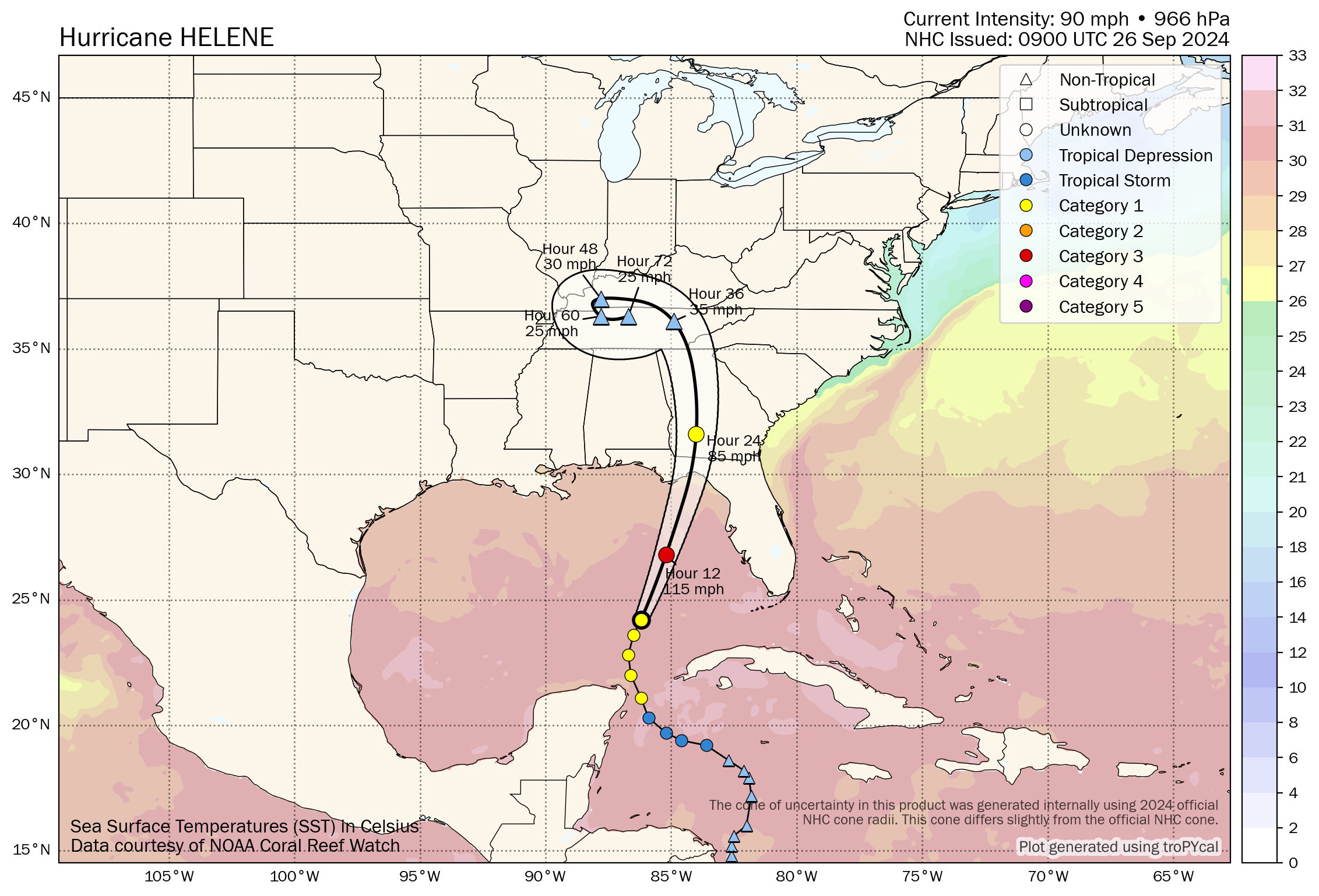
A hurricane warning is in effect from Anclote River to Mexico Beach.
The main impact in terms of wind, storm surge and flooding along the Florida Coast will be from Mexico Beach all the way down to Cedar Key and Tampa Bay (the Florida “Big Bend”). The central Gulf Coast (Gulf Shores to Panama City Beach) remains on the favorable, west side of the circulation with an offshore flow. It will be windy and wet in Panama City Beach today and tonight, but there should be no storm-surge issues there as the center comes in well to the east. There will be little to no rain along the Alabama Gulf Coast.
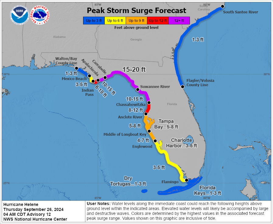
The combination of a life-threatening storm surge and the tide will cause normally dry areas near the coast to be flooded by rising waters moving inland from the shoreline. The water could reach the following heights above ground somewhere in the indicated areas in Florida if the peak surge occurs at the time of high tide:
- Carrabelle to Suwannee River, 15-20 feet
- Apalachicola to Carrabelle, 10-15 feet
- Suwannee River to Chassahowitzka, 10-15 feet
- Chassahowitzka to Anclote River, 8-12 feet
- Indian Pass to Apalachicola, 6-10 feet
- Anclote River to the middle of Longboat Key, 5-8 feet
- Tampa Bay, 5-8 feet
- Middle of Longboat Key to Englewood, 4-7 feet
- East of Mexico Beach to Indian Pass, 3-5 feet
- Englewood to Flamingo, 3-5 feet
- Charlotte Harbor, 3-5 feet
While the highest winds associated with Helene will be east of Alabama across Georgia (where widespread power outages are likely), a tropical storm warning is in effect for extreme east and southeast Alabama, where winds could gust to 40-45 mph tonight. A hurricane warning is in effect for Houston and Henry counties in southeast Alabama; winds there could gust to 70-75 mph briefly in a few spots. It will be windy over the northern half of the state Friday, although the day will be mostly dry, with gusts to 30-35 mph possible during the day.
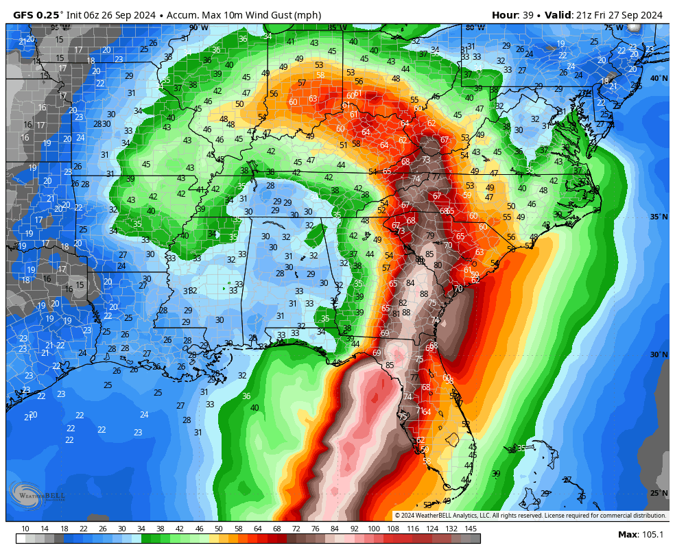
Most of the rain in association with Helene will fall over east Alabama today and tonight; a flash flood watch is in effect for roughly the eastern half of the state through early Friday morning. Rain amounts of 2-3 inches are possible there. The western side of the state will see only a few spotty showers.
There is no tornado risk for Alabama. The threat of tornadoes will be well to the east across parts of northern Florida into southeast Georgia, the Midlands and Low Country of South Carolina, and southern North Carolina.
FOOTBALL WEATHER: For the high school games across Alabama Friday night, most stadiums will be dry. The exception is over the Tennessee Valley of north Alabama, where rain is possible. Temperatures will be in the 70s.
On Saturday, UAB hosts Navy (11 a.m. kickoff at Protective Stadium). The sky will be partly sunny; temperatures will rise from near 75 at kickoff to 79 by the final whistle.
Auburn hosts Oklahoma Saturday at Jordan-Hare Stadium (2:30 p.m. kickoff). Expect a partly sunny sky with temperatures between 77 and 81 degrees.
Alabama will host Georgia at Bryant-Denny Stadium Saturday (6:30 p.m. kickoff). The sky will be mostly fair with temperatures falling through the 70s.
ON THIS DATE IN 1955: The Atlantic reconnaissance aircraft Snowcloud Five went down while investigating Hurricane Janet and was never heard from again. The commander with a crew of eight and two newspapermen reported that they were about to begin penetrating the central core of the hurricane. Hurricane Janet made landfall at peak intensity near Chetumal, Mexico, on Sept. 29. Janet’s landfall as a Category 5 hurricane on the Yucatán Peninsula was the first recorded instance that a storm of such intensity in the Atlantic made landfall on a continental mainland; prior to Janet, landfalls of Category 5 intensity were known to have taken place only on islands.
Courtesy of AlabamaWx: The official weather blog of James Spann and his team.


